Tropical Cyclone Xavier became the strongest November tropical cyclone on record east of the international date line this week, reaching Category 5 intensity on the Southwest Pacific scale just days after forecasters first flagged it as a disturbance near the Cook Islands. The storm formed while the North Atlantic was finishing an unusually quiet season, and it points to the more active Pacific season that El Niño conditions may bring.
From disturbance to Category 5
The Fiji Meteorological Service began issuing updates on November 15, 2026, on a slow-moving disturbance northeast of Samoa and the Cook Islands. The system intensified quickly. Wind shear was minimal, and sea surface temperatures were about 29°C (84°F), well above the level needed to sustain and strengthen a tropical cyclone.
Xavier was only the second named storm of the Southwest Pacific season. The first, Wati, was short-lived and formed in October.
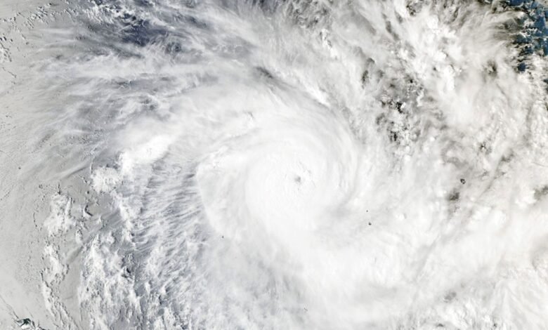
The MODIS (Moderate Resolution Imaging Spectroradiometer) instrument on NASA’s Aqua satellite imaged the storm at 02:53 Universal Time on November 17, which was 4:53 p.m. on November 16 in the Cook Islands. Forecasters then put maximum sustained winds at about 195 km/h (120 mph). Later the same day, Xavier peaked at 220 km/h (140 mph). That is a Category 5 on the scale used in the region and a Category 4 on the Saffir-Simpson scale.
Colorado State University hurricane researcher Phil Klotzbach noted that this made Xavier the strongest November tropical cyclone east of the date line on record.
El Niño’s influence
NASA satellite data showed Xavier churning along the southwestern edge of a large tongue of warm water stretching from the west coast of South America to the central Pacific. This pattern is characteristic of El Niño, which has been present in the region since June.
Xavier’s formation east of the date line, near the northern Cook Islands, was unusual. Still, research indicates that storm activity in the region typically shifts northeast during El Niño years. Studies also show that El Niño tends to favor storms that intensify at unusually rapid rates, as Xavier did.
Impacts and outlook
News reports said Xavier damaged homes and disrupted power as it passed the northern Cook Islands. The storm then met dry air and a less favorable wind shear environment, and it weakened slowly as it moved westward. That reduced the threat to Samoa and American Samoa.
Xavier is likely one of the first of several storms to affect the region in the coming months. The Fiji Meteorological Service’s seasonal outlook projects 11 to 15 named tropical cyclones this season, with the greatest risk east of the international date line. Activity in the Southwest Pacific basin typically peaks in February.
Source: science.nasa.gov